Disaster Zone Podcast: 'The Function and Role of Maritime Pilots'
Disaster Zone blog
MAY 23, 2023
Another puzzle piece in maritime transportation.

 maritime
Disaster Zone blog
MAY 23, 2023
Another puzzle piece in maritime transportation.

First State Insights
MAY 6, 2022
, speaks with Troy Mix, Associate Director of the University of Delaware's Institute for Public Administration (IPA), about the state of maritime shipping as we navigate our way out of both the pandemic and a supply chain crisis. He’s a graduate of the State University of New York Maritime College and a former merchant marine.
This site is protected by reCAPTCHA and the Google Privacy Policy and Terms of Service apply.

Data.gov
OCTOBER 19, 2016
We are excited to launch the Maritime Topic on Data.gov, a place where the diverse datasets relevant to maritime transportation can be shared and discovered. The post A Maritime Topic for a Maritime Nation appeared first on Data.gov.
Data.gov
MAY 10, 2017
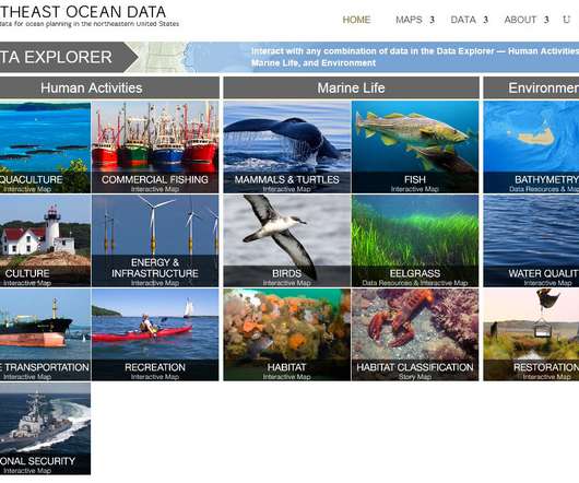
The post The Northeast Regional Ocean Council and Maritime Data appeared first on Data.gov. In the face of such complexity, local planning efforts can benefit from federally funded consistent data collection and sharing, especially when involving … Continued.

Disaster Zone blog
MAY 2, 2023
An important cog in the maritime industry.

FedTech Magazine
OCTOBER 5, 2022
Earlier this year, NGA put in place artificial intelligence (AI) technology called the Source Maritime Automated Processing System (SMAPS), which helps analysts sort through the data that streams into their systems from ships. SMAPS structures that “unstructured text…

Data.gov
APRIL 9, 2014
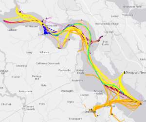
The post Maritime Limits and Boundaries of the United States appeared first on Data.gov. NOAA is responsible for depicting on its nautical charts the limits of the 12 nautical mile Territorial Sea, 24 nautical mile Contiguous Zone, and 200 nautical mile Exclusive Economic Zone (EEZ).

Expert insights. Personalized for you.


Let's personalize your content