article thumbnail

Disaster response and risk management using PNNL’s Aether framework on AWS

AWS Public Sector Blog

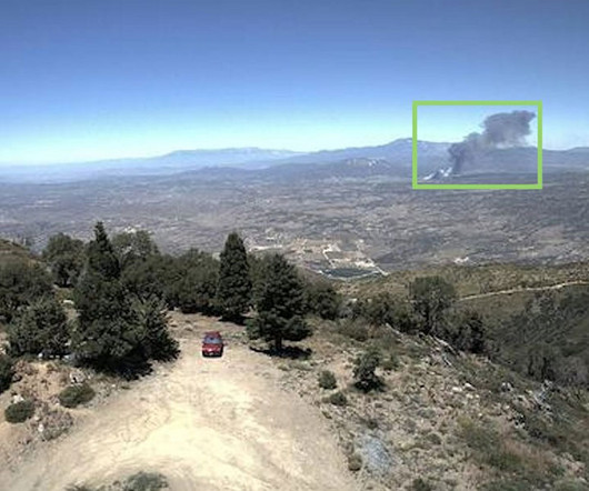
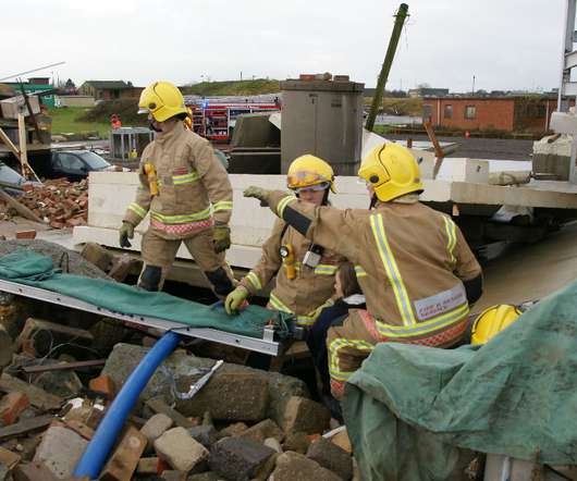
Comprehensive knowledge of critical infrastructure and real-time updates to assets and critical end-use loads drives the need for an agile data model capable of integrating disparate data types and maintaining an evergreen information baseline. Screenshot showing the EGRASS storm event simulation interface.

article thumbnail

How to detect wildfire smoke using Amazon Rekognition

AWS Public Sector Blog

Disaster response teams can use the cloud to create wildfire detection workflows that automatically deploy rapid notifications to fire incident response teams, so disaster response teams are alerted to the first signs of wildfire formation.

Insiders

Sign Up for our Newsletter

This site is protected by reCAPTCHA and the Google Privacy Policy and Terms of Service apply.

Trending Sources

article thumbnail

How AI is improving constituent experiences in government

Google Public Sector

For instance, New York State implemented Contact Center AI (CCAI) to modernize its call center operations and provide New Yorkers with real-time answers to their most common and pressing questions about vaccine safety and efficacy. In times of challenge, like the pandemic, we saw agencies rapidly apply AI to critical digital services.

article thumbnail

Google Cloud launches new sustainability offerings to help public sector agencies improve climate resilience

Google Public Sector

To help solve this problem, Google Cloud is introducing new offerings that help organizations utilize Earth observation data to better understand climate risks and provide insights to inform policies for adaptation strategies. Public sector organizations store large amounts of data in Geographic Information System (GIS) systems.

article thumbnail

Creating real-time flood alerts with the cloud

AWS Public Sector Blog

With this project, we are able to demonstrate the capabilities of the cloud to develop and implement an early warning system for floods. Researchers couple the information from these sensors with 3D mapping imagery of Panama City – data that is readily available and stored on the AWS Cloud.

article thumbnail

Building resilience: Using technology to prepare for, respond to, and recover from the unexpected

AWS Public Sector Blog

AWS also backs researchers through the Network of Earth Observation Laboratories for Disaster Risk Reduction (RedLABOT). RedLABOT was developed in collaboration with NASA Disaster Response Latin America, Esri , and AmeriGeo to address the gaps and challenges in disaster risk reduction in Latin America and the Caribbean.