Remove 2010 Remove 2019 Remove 2021 Remove Public Sector
article thumbnail

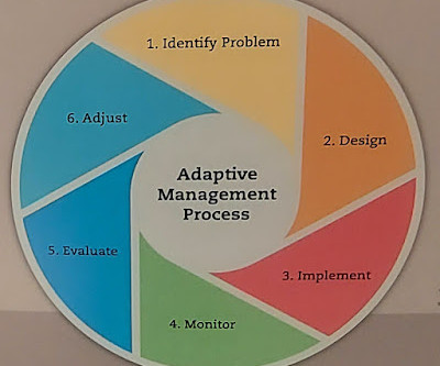
Updating the best practice elements of revitalization to include elements 7 and 8 | Transformational Projects Action Planning at a large scale

Rebuilding Place in Urban Space

A commitment to the development and production of a broad, comprehensive, visionary, and detailed revitalization plan/s (Bilbao, Hamburg, Liverpool); the creation of innovative and successful implementation organizations , with representatives from the public sector and private firms, to carry out the program. commitment and time.

article thumbnail

July 2022 - Microsoft 365 US Public Sector Roadmap Newsletter

Microsoft Public Sector

Microsoft Tech Community for Public Sector Your community for discussion surrounding the public sector, local and state governments. Public Sector Center of Expertise. We bring together thought leadership and research relating to digital transformation and innovation in the public sector.

article thumbnail

34 new or updated datasets on the Registry of Open Data: New data for land use, Alzheimer’s Disease, and more

AWS Public Sector Blog

10m Annual Land Use Land Cover (9-class) is a global map of land use/land cover (LULC) derived from the European Space Agency’s (ESA) Sentinel-2 satellite imagery at 10m resolution for the years 2017-2021. European Space Agency WorldCover 2021 & 2020 maps managed by Vito. 10m Annual Land Use Land Cover (9-class).